Psycho 486 Lecture on Path Integration and Cognitive Mapping
Review
Metric Maps
Have linear and angular distances: all geometric relations included.
Cognitive Maps
CNS record of geometric relations among surfaces in the environment used to plan movement through the environment. A mental metric map.
Maps of "Lower" Organisms
Cognitive maps that are impoverished compared to "higher" organisms.
Egocentric Coordinates
Centred on the animal. Uses current vantage point.
Geocentric Coordinates
Centred on environmental features; angles and distances between landmarks. Uses dead-reckoning.
�
Hierarchy of Ego- and Geocentric Calculation
For a point (e.g., prey item)
1. Egocentric
A. Current location (o) from dead reckoning
B. Compass heading (h)
C. Angle & distance to point
D. Compute R from h
2. Geocentric
A. Use p = Rp' + o to get point coordinates
For a line (e.g., row of trees)
1. Egocentric
A. a' (angle perpendicular to line)
B. d' (distance to line)
2. Geocentric
A. a = h + a' (geocentric)
B. d = xocosa + yosina + d'
C. L = <cosa, sina, d>
�
Animals Detect Angular and Linear Distances
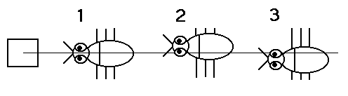
Scorpion example: egocentric estimation.
Scorpions use vibration receptors on their feet to detect the presence of moving prey.
When all receptors are present scorpions can turn directly towards the prey. Errors in turning towards the prey occur when one or more receptors are damaged.
�
Parallax Distance Estimation
Locust peer from side to side.
Gerbils head-bob.

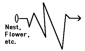
Bees turn back and look (TBL) when leaving the nest or a flower.
Piloting in Hoverfly
Piloting requires a cognitive map.
Not dead reckoning: move landmarks and fly shifts its "home space".
�
A Day in the Life of a Bee
1. Leave the nest
A. How do I get back?
i. TBLs
Select salient landmark(s)
Memorize landmark(s)
Distance of nest from landmark(s)
2. Fly to food source
A. How far have I gone?
i. Keep track of energy expenditure
ii. Keep track of travel time
3. Find new food source
A. Recognize food
B. Evaluate richness of food source
C. Collect food
4. Head for home
A. Remember food source location
i. TBLs
Select salient landmark(s)
Memorize local landmark(s)
Distance of food source from landmark(s)
B. Fly home
i. Dead reckoning
ii. Cognitive map
C. Get home
i. Identify home
Recall landmark(s) and distances from memory
5. Tell sisters about food source
A. Dance language
�
Single Landmark
Bees could not use landmarks unless food source was visible.
Bees use apparent image size and motion parallax to locate goal in relation to single landmark.
Apparent size: estimate distance between yourself and a landmark using triangulation. D = h(cotan(e)).
Also!...
Because a cylinder looks the same from all sides, bees do more than just judge the distance; them must use a geocentric map.
Note: young bees use motion parallax to judge distances; older bees use apparent size. A developmental feature.
Multiple Landmarks
The more landmarks, the easier it is to find the target.
With more than one landmark, changing landmarks size had little effect on where the bee searched.
Bees use an error weighting function. Involves using compass bearings of landmarks.
Note: Bees use a hierarchical choice system. If one landmark: use parallax or apparent size. If two or more landmarks: use compass bearings.
�
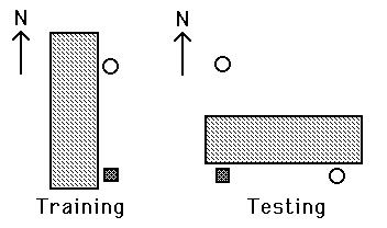
Affine Transformations
Affine transformations show metric knowledge.
Affine transformation: compressing a figure along one or more of its axes.
If bees store metric knowledge, then affine transformation of landmarks should affect their search patterns.
Trained bees on square array of landmarks with food source in centre.
Tested with square and rectangular arrays of landmarks.
Bees preferred square arrays.
Bees store metric relations of landmarks.
What Does a Bee Memorize?
Shapes and colours of landmarks.
High resolution maps of landmarks surrounding food source.
When searching for food source, near landmarks but not distant landmarks (contours).
When flying to food source/nest over great distance distant landmarks may be used.
Long Distance Bee Navigation
Bees can use the position of the sun. They can also use large environmental features as landmarks.
Landmark use is circumstance dependent.
Train when sunny; move hive overnight; open when cloudy...bees use terrain. When they dance, signal previous compass bearing. But, recruited bees flew to terrain specified feed station.
Bees represent sun's angular position relative to terrain; when sun is not visible they use terrain cues.
What Kind of Terrain Map Do Bees Use?
Route Specific
Series of pictures of landmarks lying along the route.
Not a metric map.
Geometric Cognitive Map
Supported by Gould (1986).
Capture-release experiments.
Return to Psychology 486 page
Michael R. Snyder <msnyder@psych.ualberta.ca>